VISIR is a numerical model for computing optimal maritime tracks. Its development started at CMCC from scratch in 2012. VISIR is based on a graph-search method and uses dynamic meteo-oceanographic fields for computing optimal maritime tracks. Furthermore, VISIR considers both static constraints, such as avoidance of shallow waters, as well as time-dependent constraints related to vessel intact stability. So far, ocean currents and surface gravity waves were considered in VISIR for motor vessels. In a latest development, VISIR optimal tracks are assessed for their capacity to reduce carbon intensity of the voyages. VISIR model powers an operational routing service for the Mediterranean Sea (www.visir-nav.com) and was used for mapping optimal tracks in the Atlantic Ocean (www.atlantos-visir.com). VISIR is validated versus both analytical solutions, another path planning model, and actually sailed tracks reported through AIS data.

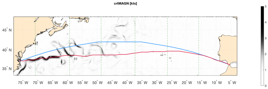
Figure 1 Geodetic (blue) and optimal tracks (red) for the Norfolk-Algeciras route accounting for both surface gravity waves and currents. Ocean current magnitude is displayed as shading and its direction as white arrows. Vertical panel stripes refer to daily timesteps of the optimal tracks – the interface between stripes is marked by a green dashed line. Departure date: 2018-06-21.
The word “VISIR” is a trademark of CMCC (https://www.euipo.europa.eu/)
VISIR is free and open software under the terms of the LGPL license, and is distributed from http://www.visir-model.net/ where also news, publications, and information on its funding projects can be retrieved.
CMCC Division
OPA – Ocean Predictions and Applications
Contacts